NYC 2016: Changing High Line pt.1

From an industrial rail to a park

I am quite sure that everyone who is into urban planning and urban development especially in industrial areas is familiar with the High Line. But if not, let’s revise the history quickly. The High Line was an elevated rail that ran from 34th Street to St John’s Park Terminal. As the goods traffic ended in 1980, a group of property owners lobbied for demolition, but thanks to local activists, planning for the reuse started in the early 2000s instead. Finally, the first part of the new park was opened in 2009.

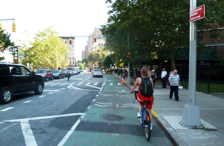
I was lucky to visit it soon after its opening in 2010. I was interested in urban fallow visions and city transforming through regeneration. The High Line was a perfect example of those optimistic visions becoming true. Back then only the first part from Gansevoort Street to West 20th Street was open. Nevertheless, I was thrilled. The transformation was successful – there was a distinctive touch of the industrial past left to see and the landscape architecture adapts to the existing structures seamlessly. The park seemed to be very popular then, and now even more. The latest figures show it has nearly 6 million visitors per year.

P1070188.JPG
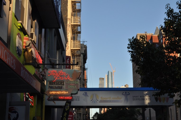
The High Line, second section.

High Line and surroundings go hand in hand

Obviously the development of the High Line park has benefited a lot from the on-going gentrification of Meatpacking District and Chelsea. The area has transformed into one of the trendiest – and most expensive – neighbourhoods, and for example Chelsea Market in that area is another successful example of industrial turned commercial. In 2005, much of West Chelsea was rezoned to allow the reuse of High Line and to encourage the residential development and the use of former industrial spaces as art galleries, while maintain the mix of residential, light industrial and retail uses.

NYC 2016 (29) muok.jpg
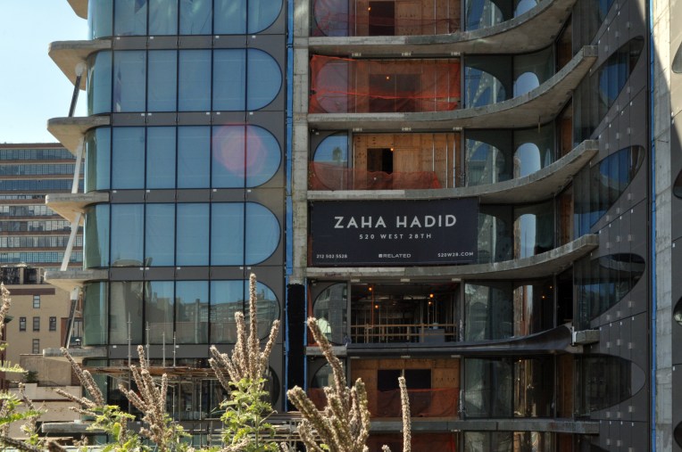
520 West 28th is advertised to the strollers on the High Line.

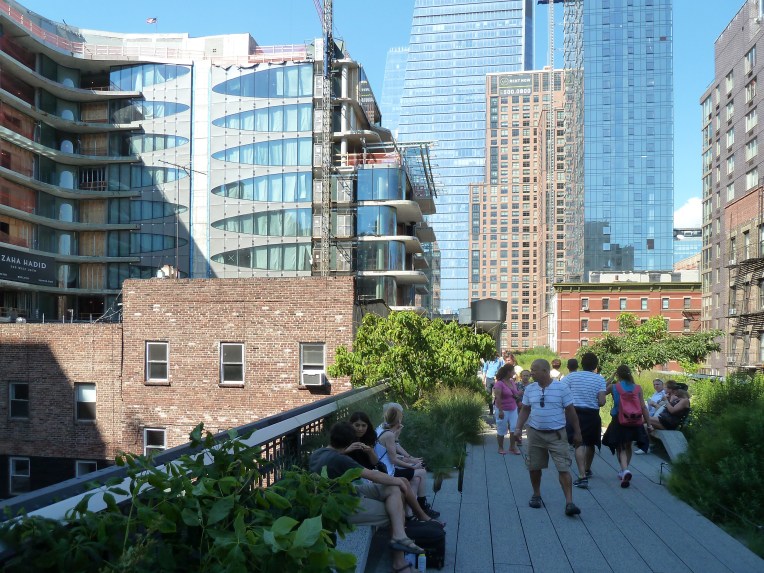
The success of the High Line and other projects has attracted high-end architecture and investments in Chelsea-Meatpacking District area. Back in 2010 there were already shiny new buildings surrounding the High Line, such as the world headquarters of IAC by Frank Gehry and the residential building “Vision Machine” by Jean Nouvel. Now I noticed the well-advertised Zaha Hadid design, which is a luxury apartment building, and Thomas Juul’s new double apartment complex. Many residential or commercial buildings, often designed by big names, are yet to be finished. Everybody is trying to ride the High Line wave. But with the visitor numbers like these, who wouldn’t? The cityscape around the High Line is mixed and puzzle-like and tolerates well different types of buildings. The big object-like buildings are observed from an elevated level, which makes the scenery far more interesting than observing from the street level.  The starchitect designs are changing the High Line more like an architecture outdoor gallery though, adding the hype and making prices skyrocket.

NYC 2016 (48).JPG
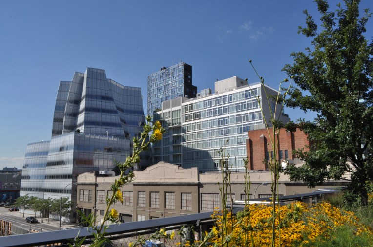
IAC headquarters and the Vision Machine seen from the High Line.

At the southern end there is the new building of Whitney Museum of American Art. It is designed by Renzo Piano, and includes approximately 50,000 square feet of indoor galleries and 13,000 square feet of outdoor exhibition space and terraces facing the High Line. I think that along the outdoor architecture gallery the museum fits in the place perfectly. Coming from the north, it frames the view elegantly.

NYC 2016 (148)_muok.jpgThe terraced building of Whitney Museum of  American Art.

NYC 2016 (21)_muok2.jpgWhitney’s main entrance creates a pleasant plaza in the front.

Hudson Yards development

The third section of the High Line opened in September 2014. The part seems to be still very much in progress, especially because there is a large construction site next to the railyard. I found out that this site is the largest private real estate development in the history of the United States, the Hudson Yards. When completed in 2024, 125 000 people a day will work in, visit, or live in Hudson Yards. I was surprised to find out that the High Line is barely mentioned in their site although one third of it literally wraps around the development site. The High Line is featured as “a neighbouring park”. Curious!
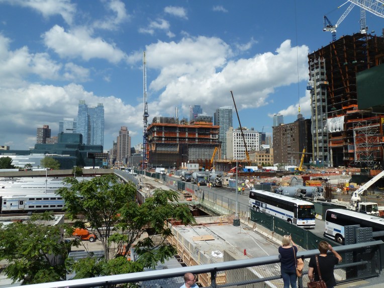
P1070146.JPGHudson Yards site.

Success attracts everybody

The smell of success attracts the most imaginative projects to hop on the High Line train. Recently, a project called the Lowline, an underground park, got New York City’s official approval. Although this project is not connected with the High Line as far as I can tell, just the name alone connects it with its predecessor. The Lowline Lab is yet to be visited, hopefully there is time for it next week.

More reflecting on the High Line following soon in an another post!

-Laura

NYC 2016: The background of a transforming streetscape

One of our themes for the month here in NYC is streetscape and the way it is being altered to meet the needs of the ever growing metropolis.Transforming streetscapes that have been designed to mainly meet the needs of car traffic to pedestrian-friendly environments is an ever-growing trend both internationally and in Finland. Numerous cities have made a clear (re)prioritization between different modes of transportation. After a long period of car-first thinking key priorities are now pedestrian – cycling – public transport – private cars. Attitude change is a good start, but we also need good design solutions to create functional and comfortable, pedestrian-friendly streets and squares also in busy locations.

Background research

For background research of the ideas behind these changes we’ve looked at Streetfight by Janette Sadik-Khan and Seth Solomon and Walkable City by Jeff Speck. The first is essential in telling the story behind the transformations of the changes in traffic planning in NYC. Janette Sadik-Khan was was the commissioner of the New York City Department of Transportation from 2007-2013. The book explains how the big transformations in NYC’s streets started to take shape during her time in the office. The latter, Jeff Speck’s bestseller is a good theoretical overview on why walkability should be a major concern among planners and how it could be achieved. Jeff Speck has been a popular lecturer since his book came out and he visited also Finland in 2015.

Since Jan Gehl is one of the important figures in reshaping the NYC’s streetscapes we also looked at his books Life Between Buildings and Cities for People. These two books give a good idea of Gehl’s design philosophy that has influenced planners around the world.

Lukemiset.jpg
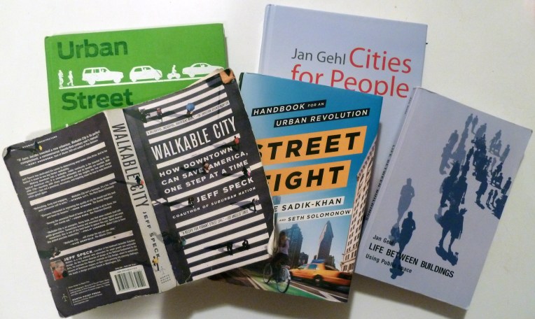
Our main reads for this trip – all of which are highly recommendable!

Expert meetings

In order to get a deeper understanding of the issues that the planners and designers are tackling here we are visiting some local colleagues here. We are going to visit the National Association of City Transportation Officials (NACTO) who have published excellent manuals regarding streetscape design. Urban and Transit Street Design guides and Urban Bikeway Design Guide all give an excellent answers not only to the question what should be done to streets but also good explanation of why and how these changes should be made.

After NACTO, we are meeting planners at WSP-Parsons Brinckerhoff and New York City Planning Department. We hope that these meetings will give us a better understanding how designs are put into practice here in NYC.

NACTO-manuaali.jpg
Boulevard design from NACTO’s Urban Street Design Guide, 2013

The solutions

Besides the readings and discussions with the planners we are of course looking at the actual solutions in real life. We are trying to experience the streets on NYC in diverse ways and with different modes of transportation. In this field research part we are trying to investigate the streets in order  – as Jeff Speck says about his book – not to explain why or how cities work but what works in the cities. We are going to look at the more permanent and interim design solutions that have been made in the streets and try to evaluate how they work.

We have started our studies on the streetscape and we got a good start by running and cycling about 10km through Manhattan in the Summer Streets event which will be the topic of the next traffic post.

-Tomi

Action research.jpg
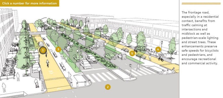
Helsinki City Planner learning from New York in action


NYC 2016: First impressions

NYC 2016 (69).JPG

We arrived in New York City three days ago. The city is strikingly big! We took an airport train and subway from JFK to Harlem and Laura managed to sleep for quite a bit on the way – the trip through highly urban neighbourhoods took about 1,5 hours. We are both excited and anxious about the hugeness and endless stories of the city – how much can you even cover in only one month?

Our study program for this August includes four themes: urban regeneration, transforming streetscape, waterfront development and using public space bottom-up. In all of these we are interested in interfaces of different spaces, user groups or forms of development. We try to give you some insight on these topics while comparing our observations with our daily work.

– Laura & Tomi

Co-op city

Tomi was part of a multidisciplinary team that won the Nordic Built Cities Challenge’s Kera local challenge. The team consisted of 13 members and 3 experts from B&M architects, WSP Finland and Sweden, Setlementtiasunnot, Päivi Raivio and Forum Virium. According to the jury report the team’s proposal called Co-op city “proposed a great concept focusing especially on the social, humanscale aspect of city development – true to Nordic values and the competition criteria.” Tomi was responsible in WSP Finland especially for the Co-op concept’s urban regeneration process, the 20 minute neighborhood urban context and the fine-tuning of the urban structure originally made by B&M architects to meet the competition objectives.

Co-op-city_20-minute

Arkkitehtuurivisioita ja tunnustusta Tampereelle

hämeenpuistoUUSI10

Opiskelin Tampereen teknillisessä yliopistossa ja minulla on edelleen vahvat siteet sinne. Perustimme aikoinaan opiskelukavereitteni kanssa Tilanne-kollektiivin, jolla oli jonkin aikaa myös työhuone-kahvila Itsenäisyydenkadulla.

Viisi vuotta sitten teimme Tilanne-kollektiivin kanssa taideteoksen tulevaisuuden rakentamisesta Tampereen taidemuseon Onko totta?-juhlanäyttelyä varten. Yle kaivoi esiin visiot ja vertaili niitä Tampereen nykyisiin ja tuleviin hankkeisiin. Kävi ilmi, että aika moni visio onkin toteutumassa. Tampere muuttuu kovaa vauhtia ja siellä halutaan ottaa paikka Suomen toisena “metropolina”.

Ylen juttu Onko totta? -näyttelystä:
http://yle.fi/aihe/artikkeli/2016/04/22/onko-totta-muuttuivatko-arkkitehtien-utopiat-tampereesta-todeksi

Tällä viikolla Tampere emännöi SAFA:n vuosittaisia Arkkitehtipäiviä. Niiden yhteydessä jaettiin SAFA-palkinto, jonka sai Tampereen arkkitehtuuriviikko. Olen itse ollut vuosien varrella jonkin verran mukana järjestelyissä, vaikka olenkin jo kauan asunut Helsingissä. Olen ylpeä ja iloinen vapaaehtoisvoimin järjestettävän, mutta laadukkaasta ohjelmastaan tunnetun tapahtuman menestyksestä. Hyvä Tampere!

Palkinnosta lisää SAFA:n sivuilla:
http://safa.fi/fin/ajankohtaista/uutiset/?nid=616

-Laura

Nembi launched

Hello,

We are architects Laura Hietakorpi and Tomi Jaskari. Nembi.fi is the site where we blog and showcase our projects. Welcome!

Laura & Tomi

Laura_Tomi_Rooftop2